Author: admin

MWCD Invites You to Capture the Canvas for a Chance to Win $1,000!


The Muskingum Watershed Conservancy District (MWCD) invites you to hit the trails this summer for a chance to win fabulous prizes while having a great time outdoors with your family and friends!

The MWCD has partnered with five local schools in a promotion that encourages residents to get outdoors and explore the trails at MWCD parks. With materials given by MWCD, students painted canvases that will be on display on MWCD trails throughout the district. Participating schools and the locations of their artwork are:

  • Conotton Valley High School: Atwood Lake Park
  • Lucas High School: Charles Mill Lake Park
  • New Philadelphia High School: Pleasant Hill Lake Park
  • Caldwell High School: Seneca Lake Park
  • Starlight School: Tappan Lake Park

Guests are encouraged to try and find all five canvases at each of the MWCD parks and can have a maximum of three entries. First prize is $1,000 cash sponsored by Encino Energy, second prize is a weekend stay at the deluxe log cabin at Pleasant Hill Lake Park, and third prize is a one-day boat rental from a MWCD-operated marina.

“We are extremely excited to collaborate with local school districts to encourage people to explore our trails and experience nature at one of our parks,” said Ryan McCleaster, MWCD Chief of Recreation. “These students are so talented, so to also have an opportunity to display their artwork in such a unique way is an honor.”

The artwork will be on display, and the contest will run from Memorial Day through Labor Day. To enter, visit one of the MWCD park locations and search for the canvas on the trail. Once found, take a “selfie”, or have someone take your photograph. The photo must include yourself, along with the canvas in the background to prove you found the canvas. Visit www.mwcd.org/capturethecanvas to enter your information, upload your photo, for contest rules and trail maps. Must be 18 years of age to participate.

May is American Wetlands Month

Wetlands are defined by areas of land that are saturated with water for most of the year. They often occur at the mouths of rivers, around lakes and streams, as well as alongside coastlines. There are four types of wetlands that occur in Ohio: Marshes, bogs, fens and swamps (source from Ohio DNR website). One of the most significant wetlands in the Muskingum Watershed is the Killbuck Marsh in Holmes County. Killbuck Marsh Wildlife Area is a protected area that covers 5,703 acres located 2 miles east of Shreve.

Marshes are formed when a water body starts to fill up with peat (decaying plant debris). As the bottom of the pond fills with peat, woody and herbaceous plants will grow. The peat, along with the plants growing on the bottom of the pond, help to create a water supply table that acts as a filter for incoming water, as well as flood control, soaking up excess water like a sponge.

In 2015, with assistance from MWCD’s Partners in Watershed Management Program funds, the Holmes County Park District acquired 63 acres of land surrounding Killbuck Marsh, and another 35 acres in 2017. The acquisition of this property helps to ensure continued protection of this resource, which includes maintaining good water quality and wildlife habitat. This also allows for the area to be used for educational programming.

The Muskingum Watershed Conservancy District recognizes the valuable role wetlands play in the environment to maintain clean water, protect biodiversity, and to provide unique recreational opportunities for the public. Collaboration with other organizations to manage, protect and enhance the value of wetlands found in the Muskingum Watershed is important to MWCD and is part of the 5-year strategic plan for the Conservation Department.

It’s a Dog’s Life at MWCD Lakes!

The Muskingum Watershed Conservancy District (MWCD) is pleased to announce that all MWCD campsites are now officially 100% pet friendly! In addition, select cabins at each lake will now allow pets.

“We love our pets and know our guests do too.  Over the last few years, we have seen an increase in popularity of families traveling and camping with pets,” said Adria Bergeron, Director of Marketing and Communications. “Our camp areas have been mostly pet-friendly for many years, but demand has caused us to review our rules, and as a result pet restricted areas are a thing of the past.”

Some tips on camping with your well-behaved pet include ensuring they are up to date on required vaccinations, registration, and identification. In addition, don’t forget to pack a dog bowl and food, dog water dish, outdoor toys, and most importantly, a leash!

The MWCD lakes offer hiking trails, marinas with boat rentals, and plenty of green space to allow your furry family member to enjoy nature. While Atwood Lake Park is currently the only location with a dog park, more locations are under consideration in the future.

While pets will be permitted in all areas, they must be on a leash and owners must clean up after their pets.  Those not following our rules will be asked to leave our parks.  And for cabins, a non-refundable $50 per pet fee will also be applied for cabin guests.

MWCD Board Votes to Cut Property Assessment

Property owners receive a total of $4 million in savings annually

Property owners within the Muskingum Watershed Conservancy District (MWCD) will see their property assessments paid to MWCD reduced by 66 percent, from $6 dollars to $2, thanks to the approval of the assessment-reduction plan voted on recently by the MWCD Board of Directors. 

“We have always been good stewards of these public funds and are very pleased to allow residents in the watershed to keep more of their hard-earned dollars in their pockets,” said Craig Butler, MWCD executive director. “We are making this reduction because the district’s financial position has changed positively.  We have been fortunate to earn and invest nearly $200 million in our public-use facilities and recreational areas, and now for the second time, the Board has voted to extend those benefits to the property owners in our watershed by reducing the assessment collection.”   

The assessment originally was levied in 2009 at $12 per parcel and was then cut to $6 in 2015. Assessments are collected through landowners’ county property tax payments, and the funds are required to be used by MWCD on the operation and maintenance of the system of 16 dams and reservoirs. The system was constructed nearly 90 years ago for flood reduction and water conservation benefits in the Muskingum River Watershed, as well as other important conservation and reservoir management projects.

The assessment reduction will result in an estimated $4 million overall reduction in the total amount of assessments collected in 2024 by the MWCD.  However, the district will still meet its financial commitments to the federal government for dam and reservoir maintenance, as well as for conservation and reservoir management projects. Routine financial reviews will be very important and, in the event of any major changes in the district’s financial position, corresponding adjustments could be made to assessment levels.

Assessment funds are also used to support the work of other regional agencies and groups involved in conservation programs, water quality issues, and flood reduction and mitigation projects through the Partners in Watershed Management (PWM) Project Assistance Program. The PWM program provides assistance to local communities, agencies and groups involved in projects and programs that support the conservation and flood control aspects of the Mission of the MWCD. The PWM program, approved by the Board of Directors in June of 2009, has provided over $12.2 million in grant funding for 177 projects.

“There is a tremendous need across the watershed to provide funding to communities, universities and other conservation organizations that regularly partner with us on projects that protect the people of our region,” said Butler. “These projects help to prevent costly flooding, minimize soil erosion and nutrient loss from agricultural operations, assist with upgrading essential community services, and preserve and rehabilitate sensitive lands for public use.  MWCD is proud to be a sponsor of these projects as they support our core mission and allow us to give back to the communities that are in our backyard.” 

In addition, the MWCD has spent assessment funds on shoreline stabilization projects at the MWCD lakes and dredging of the lakes. Assessment revenues by law cannot be used to pay for projects that enhance or improve the MWCD’s recreational programs and facilities, and all expenditures must be covered by guidelines stipulated in the Amendment to the Official Plan of the MWCD that was approved in 2005 by the Conservancy Court and the Board of Directors.

The MWCD collects assessments from owners of property in all or portions of the following counties: Ashland, Belmont, Carroll, Coshocton, Guernsey, Harrison, Holmes, Knox, Licking, Morgan, Muskingum, Noble, Richland, Stark, Summit, Tuscarawas, Washington and Wayne.

Welcome Back Campers and Boaters!

MWCD Staff held a virtual public meeting on April 12 to welcome back campers and boaters for the 2023 season. In case you missed it, the recording is now available on YouTube! 

Whether you camp with us for the season, or occasionally throughout the year, this meeting will provide updates from MWCD Staff on exciting things to expect throughout the year. 

Meeting agenda:

  • Welcome back campers! 
  • Introduction of new Chief Ranger 
  • Program overview/ Communication
  • Campground Rules Overview
  • Upcoming Projects
  • Q&A

Click on the image below to view the recording on YouTube.

CD 

Have You Heard of the Chippewa Subdistrict

Did you know that MWCD owns and operates a flood control system in Medina and Wayne counties that is separate from the Muskingum Flood Control System? The system is operated by the Chippewa Subdistrict of MWCD.

Chippewa Subdistrict was formed in the 1960s through a grassroots effort led by local business owners and farmers to lessen the devastating impacts of flooding along Chippewa Creek, which starts in northern Medina County and flows in a southeasterly direction to where it meets the Tuscarawas River near the town of Clinton. The Chippewa Creek watershed encompasses 188 square miles. The eight dams and associated channel improvements along Chippewa Creek and two other tributaries, Little Chippewa Creek and River Styx, were designed and built by the Soil Conservation Service (SCS), now called the Natural Resources Conservation Service. The SCS built hundreds of similar dams all over the United States. However, to build the Chippewa system, a local sponsor was required. MWCD was asked to fill that role and was instrumental in acquiring property and easements for construction of the dams and channel improvements. Construction of the project was supported by federal funds at a total cost of $12,190,000 with a local cost-share of $2,268,000. When the last dam was built in 1980, the entire system was handed over to the Chippewa Subdistrict to own, maintain, and operate.

The Chippewa Subdistrict is its own entity and was created and is operated in a similar fashion as the larger MWCD. Chippewa has a project coordinator on staff that keeps the system operating smoothly and the chief engineer for MWCD also serves as chief engineer for the Chippewa Subdistrict. The subdistrict also has its own Conservancy Court and maintenance assessment which generates $320,000 per year. Those funds are used to maintain the eight dams and associated spillway systems, remove logjams and debris that accumulate throughout the channel system, maintain access along the channel system, and maintain over 600 drainage structures along the channel. Local contractors are utilized for much of the maintenance work and in doing so, Chippewa supports many small businesses in the local community.

For nearly five decades, the Chippewa Flood Control System has been a great success in preventing disastrous flooding for communities along Chippewa Creek including Seville, Sterling, Creston, Rittman, and Clinton. The last devastating flood occurred in 1969 when severe thunderstorms moved from Lake Erie into Ohio’s north coast communities on July 4th. This line of storms became stationary for eight hours from Toledo southeastward through Fremont, Norwalk, Ashland, and Wooster. 10-14 inches of rain fell in a band heading southeast from Ottawa County to Wayne and Holmes Counties. Massillon, just east of that area, received six or more inches of rain. Most of Ashland and Wayne Counties were flooded and isolated for two days after the flood. Killbuck Creek in Holmes County rose 20 feet, its highest known level.

Chippewa’s dams range in size from 27 feet to 55 feet tall and from 470 feet to over 2,600 feet in length. Four of the dams are “dry dams” meaning they do not impound water during normal conditions, while the other four are “wet dams” where a permanent reservoir is impounded behind the dams. All eight dams are regulated by the State of Ohio and are in complete compliance with state standards and regulations.

If you ever find yourself driving west on Interstate 76 about two miles before the Interstate 71 intersection, look northward and you will see Hubbard Valley Dam, one of Chippewa’s dams.


Boris Slogar                                                                                                                                                          Chief Engineer

This article was featured in MWCD’s quarterly newsletter, LakeViews. To join our LakeViews mailing list, call 330-343-6647 or visit MWCD.org 

MWCD Actively Engaged in Restoring Legendary Status of the American Chestnut

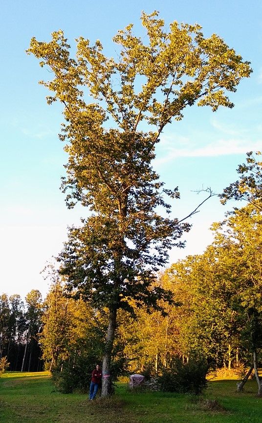
The American chestnut was once the dominant economically and ecologically important tree species in eastern North America. Among the tallest, largest, and fastest-growing trees, and often found in both urban and rural settings, nearly four billion American chestnut trees covered the region. Facing extinction from a fungal blight in the early 20th century, it has become the embodiment for landscape-level ecological disasters. By the 1930s, entire ecosystems collapsed, and economies shifted dramatically. The local traditions and culinary history that centered around the American chestnut faded into the past along with the deaths of millions of trees.

In the aftermath of the disease that swept across Appalachia, there still were some remnant trees struggling to survive. These trees, more of a scrubby bush than an actual tree, were living genetic stock that offered hope of reintroducing the chestnut into our landscape.

Since the 1980s, The American Chestnut Foundation (TACF) has been working to create a blight-resistant American chestnut tree by crossing it with blight-resistant Chinese chestnut varieties. Carefully controlled pollination and selection of trees that exhibit blight resistance, nut quality and timber producing characteristics have brought us to the point of experimental reintroduction into forested areas. Developing trees with good characteristics in isolation is only half the battle. The other half is studying how these seedlings survive in a more natural landscape.

The Ohio chapter of TACF has participated in this national effort and has also conducted independent chestnut breeding research with Dr. Greg Miller of Ohio TACF and Empire Chestnut Company, Carroll County. Miller has been breeding and selecting chestnut trees with tall timber-type growth form, blight resistance, and other beneficial characteristics for over 40 years.

MWCD has the unique ability to plant, monitor, and manage test plantings within the watershed. These small plots help managers assess tree survival and growth and are an important first step in better understanding how they can be part of Ohio’s forests once again.

In April 2022, MWCD planted 200 chestnut trees – 100 from TACF’s backcross breeding program, and 100 from Empire Chestnut Company. These trees were planted near Tappan Lake in Harrison County. MWCD’s Conservation Department, in partnership with TACF, Empire Chestnut Company, and researchers from The Ohio State University will be monitoring the growth and survival of the trees as they start to fill the canopy. When these trees reach nut-bearing age (approximately five years), MWCD will survey the surrounding forests and fields for evidence of natural regeneration.

These renewed chestnut trees have quite a lot to offer beyond timber, wood products, and food. By reintroducing the chestnut into the forest, we make our forest ecosystems more resilient, more biodiverse, and able to withstand future challenges. MWCD is proud to participate in this critical research and long-term forest management for the greater good of our Ohio landscapes, wildlife, and people.

These trees and their seedlings will become part of our diverse Ohio forests filling that ecological niche once lost. MWCD is making the important first steps needed to achieve sustainable chestnut timber harvest in Ohio. This will ultimately return chestnut wood products to local markets for the first time in over 100 years.


Matt Thomas                                                                                                                                                          Chief of Conservation

This article was featured in MWCD’s quarterly newsletter, LakeViews. To join our LakeViews mailing list, call 330-343-6647 or visit MWCD.org 

110 Years Ago Today: The Great Flood of 1913

The greatest weather disaster in Ohio history began on March 23, 1913, and brought about 3 months of rain (6-11 inches) over a 5-day period, flooding every stream, creek, and river in Ohio. The flood destroyed homes and property, effectively eliminated the canal system in Ohio, and damaged 69 bridges in the Muskingum River Watershed. The flood led to more than 400 deaths in the state, including 11 in the Muskingum River Watershed. Experts estimate that in today’s dollars, Ohio’s total damages would have been around $3 billion.

The Great Flood of 1913 spurred the development of conservancy districts in Ohio with the passage of the Conservancy Act of 1914. On June 3, 1933, 20 years after the Great Flood, the Muskingum Watershed Conservancy District (MWCD) was established. As the largest of the conservancy district, the watershed spans all or portions of 27 counties, covering more than 8,000 square miles, and is home to 16 dams and reservoirs that provide flood reduction and water conservation benefits for the property owners and residents of the region. The flood reduction system has been credited by the federal government with saving an estimated $8 billion worth of potential damage from flooding since its construction 90 years ago.

Today, we reflect on the 110 years since the Muskingum River Watershed, Ohio, and much of the Midwest was devastated by the Great Flood of 1913 and we thank our forefathers for their incredible vision and dedication to establish a system of dams and reservoirs that significantly reduce flooding today.

Celebrating 90 Years of Flood Reduction, Conservation, and Recreation

Age is just a number, right? 55 is the new 35, or so I am told. We hear these axioms all the time and it made me think about age in a different way. MWCD is turning 90 years old this year and if we think about this in terms of business survival, that is excellent! The prevailing theory, though unconfirmed, is that only about a half a percent (0.5%) of all companies have what it takes to last 100 years. This means that centennial firms—and MWCD is getting close—truly do have a lot to celebrate. In our case, turning 90 is unique from a business longevity perspective, but we see it as “just a number.” While we make time to honor and celebrate our past, we as stewards of MWCD, are looking forward and making plans for MWCD to be active, healthy, and a positive influence in the region for decades to come.

Speaking about honoring our past, immediate past Executive Director, John Hoopingarner took to the pen in 1993 to mark the 60th birthday of the MWCD. He eloquently reminded us of the will and foresight of strong leaders instrumental in our founding and success, none more-so than Bryce Browning, and predecessor of John, have laid and protected a strong foundation for which the modern-day MWCD is built. All of us in the Muskingum Valley and Ohio should be thankful for them and what they did.

Moving forward 30 years and we are just finishing a new strategic plan that will guide our actions, investments, and direction for the next five years, while also looking out 20 years. If you have ever gone through a robust planning process like this, it can be both rewarding and difficult. Difficult in the sense you are trying to juggle the day-to-day activities of running the business, while at the same time coming together with your staff and stakeholders to plan for the future. The result of this, not surprisingly, has MWCD continuing its excellent mission and work reducing the threat of flooding across the entire district while supporting conservation efforts and offering recreational opportunities – our three core pillars. However, we are contemplating how to do this differently, such as working with communities on issues like stormwater management and using green infrastructure to slow these waters before they enter our lakes. Likewise, we are putting a spin on our other long-successful pillar, recreation. Our last several strategic plans had MWCD focus squarely on investing in replacing infrastructure and building new recreational – camping – assets at our parks. While we will continue to work on areas still needing some TLC, we are looking forward to what our recreation mission will look like in the future. You will hear us talk about “reimagining recreation” and working to define what this means. Lastly, and somewhat new to the MWCD, is a large focus on conservation. This means many things. From improving our own sustainability and environmental performance, to planning for major investments of time and resources in the watershed to help improve water quality with our partners like the Department of Agriculture, Soil and Water Conservation Districts, farmers, and many others. So, as you can see, we are charting a new course, looking forward to new opportunities, but respecting our past traditions and continuing to support our mission and values.

In thinking how to close this editorial, I couldn’t find any better way than how John closed in his 1993 version…“our presence in the Muskingum Valley has enhanced our lives with countless benefits: jobs, commerce, industry, recreation, conservation, flood control, and on and on. Proud? Yes…and if you’d like to learn more about the district, give me a call. I never tire of telling the story.” I too, never get tired of telling our story. Happy 90th birthday, MWCD! You look great!

Craig Butler                                                                                                                                                            Executive Director

This article was featured in MWCD’s quarterly newsletter, LakeViews. To join our LakeViews mailing list, call 330-343-6647 or visit MWCD.org 

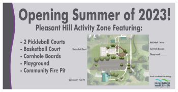
New Activity Zone is Coming to Pleasant Hill Lake Park!

Two pickleball courts, a basketball court, playground, cornhole, community firepit, and swings with a scenic view of the lake are now under construction at Muskingum Watershed Conservancy District’s (MWCD) Pleasant Hill Lake Park in Perrysville, Ohio.

The amenities, totaling nearly $1 million, are scheduled to open by Memorial Day, and are part of the MWCD Master Plan investing approximately $195 million at Atwood, Charles Mill, Piedmont, Pleasant Hill, Seneca, and Tappan Lakes to improve infrastructure and construct new campground areas.

“We are excited to see these amenities under construction,” said Ryan McCleaster, MWCD Chief of Recreation. “We recently completed a strategic plan which includes the imperative to Reimagine Recreation. This project is one great example of many amenities that we plan to bring from idea to reality over the next 5-years at MWCD lakes and parks.” 

To date, 12 projects have been completed at Pleasant Hill Lake Park since 2016. These projects include a boat storage lot, sanitary collection system improvements, activity center improvements,  two new campgrounds and four renovated campgrounds, two new and one renovated restroom/shower building, and 10 new log cabins featuring indoor fireplaces and outdoor hot tubs. The total investment at Pleasant Hill to date is $26.1 million.

MWCD has become a model for outdoor recreation, drawing guests from across Ohio and the U.S. We are leaving a legacy for future generations to enjoy the benefits of recreation in the Muskingum River Watershed. 

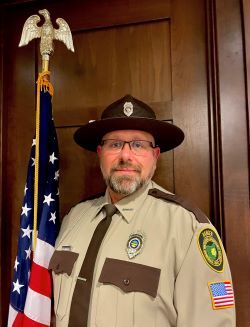
MWCD Names Chief Ranger

Patrick Brockmeier has been named Chief Ranger for Muskingum Watershed Conservancy District (MWCD) to lead the ranger department.  He will oversee 34 Rangers whose duties range from patrolling camp areas, cottage areas, and lakes, to providing Ohio Boater or Hunter Education Courses to the community. They also conduct safety checks, respond to noise complaints, criminal violations, and assist other nearby agencies.

Brockmeier has been employed by MWCD as a variable Ranger at Seneca Park since 2019 while also working as a full-time probation officer for Marietta Municipal Court. He has prior Chief experience as the Matamoris Police Department Chief of Police and the Beverly Police Department Chief of Police. He also serves as part-time faculty at both Washington State Community College and Hocking College as an OPOTA Instructor, Ohio Correctional Officer Instructor, and Natural Resources Instructor.

“I am excited about this new opportunity at the MWCD,” said Brockmeier. “I consider the opportunity to serve the MWCD to be a great privilege and responsibility, one that I will approach with professionalism, and a commitment to work in partnership with our entire community.”

Patrick earned his Bachelor of Arts degree in General Studies, with a concentration in Political Science through Marietta College, his Associate of Applied Science degree in Criminal Justice through Washington State Community College, and an Associate of Arts degree in General Studies through Marietta College. He earned his Ohio Peace Officer Training Certification through Hocking College

“We are pleased to welcome Patrick to MWCD as our new Chief Ranger,’’ said Executive Director, Craig Butler. “His education and background in law enforcement, as well the experience he has from working as a ranger for us since 2019, brings an insight to our organization and will make him an effective leader. He has a desire to implement new ideas to further enhance our community policing style of law enforcement and make him the perfect fit for our organization.”

Geophysical Survey to be Conducted at Atwood Lake

An upcoming project will take place on portions of MWCD property at Atwood Lake. The project will include a Geophysical Survey conducted by Dawson Geophysical Company on behalf of EOG Resources. We have discussed and worked with both Dawson and EOG in advance of the project. For your convenience we have included below some frequently asked questions regarding this type of project. Please review this information at your convenience. We appreciate your patience while this project takes place.

What is a geophysical survey?
Geophysical surveys use acoustic waves to create images of the earth through analysis of vibrations from those waves. Surveys can be conducted on land and water. It’s basically like taking a “sonogram” beneath the surface.

Why is a geophysical survey needed?
The oil and gas industry uses the survey to image the earth’s subsurface layers to determine oil and gas reserves, along with other geologic features which could affect the exploration and development of the reserves.

How will this project affect me?

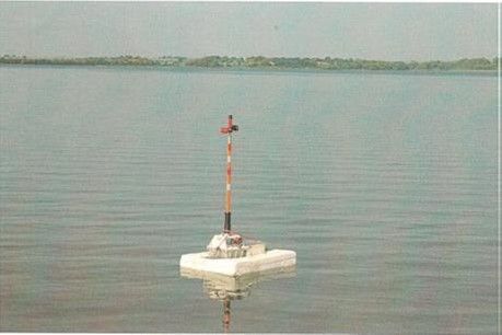
Throughout the duration of the project, you may experience temporary inconvenience in certain areas while recreating on land and on the water at and around Atwood Lake. This could include increased foot, vehicle, and equipment traffic, temporary boat traffic pattern changes, equipment placement and retrieval in and around MWCD lands, facilities, and on the lake. Please see the pictures below for examples of some of the equipment to be utilized during the project. No equipment is being placed on cottage area lots and access to cottage area lots is prohibited.

Has MWCD allowed geophysical surveys in the past?
MWCD has permitted both large and small geophysical surveys in the past, including at Atwood.

What is the timeline for this project?
Currently the project is expected to start in January-February of 2023. The project is anticipated to be completed by the end of April 2023.

Where will the geophysical survey take place?
The entire survey is being conducted for a ~135 square mile area in Carroll, Stark, and Tuscarawas counties Ohio. A smaller portion of the entire survey is expected to be conducted at pre-determined global positioning system (gps) points on approximately 3,000 acres of MWCD land and water on the western side of Atwood Lake.

What steps are involved in a geophysical survey?
A geophysical survey typically involves multiple steps. They include a cultural survey, data recording and collection, and data analyzation.
1. Cultural Survey: Is the first step of the process to identify cultural points such as utilities, structures, and other items. Safety buffers are added to subsequently lay out a grid of energy sources and receivers.
2. Data Recording and Collection: The acoustic waves are created by an energy source at the surface. Acoustic wavelets then travel through subsurface layers of rock and then travel back to the surface, where the data is recorded by receivers at the surface.
3. Data Analyzed: This recorded data is subsequently analyzed to produce an image of the subsurface layers for use in exploration and development.

Who is Dawson Geophysical Company?
Dawson Geophysical is a leading provider in North America for onshore data acquisition services, operating in many of the larger producing basins including the Appalachian Basin. Additional information can be found at dawson3d.com.

What is the benefit to MWCD?
Primarily, the survey will benefit the development of MWCD’s mineral reserves to develop these reserves in a safe, reliable, and efficient manner. The survey information can allow the operator to reduce risk regarding cost, safety, and negative effects to the environment by allowing for more accurate planning of well locations and more accurate design of drilling and completions operations. The information can also reduce the probability of technical issues or hazards for the drilling and operations process. Additional benefits to MWCD could include a better picture or understanding of the geology underlying the lake and MWCD lands, as well as being a good steward and partner for private landowners adjacent to and within the entire survey to realize the benefits.

Who can I contact if I have any questions?
If you have questions, please contact 330-343-6647

Receiver on a buoy
An example of a receiver on water    An example of a receiver on land

Subscribe

Please enable JavaScript in your browser to complete this form.
Name
I'm interested in information about: