The dams and reservoirs of the District are over 70 years old and in need of major upgrades and deferred maintenance. Over the years the District has attempted to provide this maintenance with its limited funds from recreation and lease payments. However, these funds are no longer sufficient to meet the needs of the dams and reservoirs, which the District estimates will total more than $200 million over the next 20-years. See the Amendment to the Official Plan
All non-assessment-exempt parcels within the legal boundary of the MWCD, approximately 700,000 parcels, are subject to the assessment.
Money collected from the assessment is being used to match funds from the U.S. Army Corps of Engineers for repairs to the 14 dams in the Watershed, the improvement of local flood protection, the removal of log jams from area streams, the dredging of sediment from Watershed reservoirs, the reduction of sediment in streams through erosion control and best management practices, the improvement of water quality by reducing acid mine drainage, the reduction of hydrogen sulfide built-up in Watershed reservoirs, the reduction of pollution loads from septic systems and inadequate treatment plants, and for other programs in the Watershed that promote flood reduction and water conservation. Assessment funds cannot be used for recreation projects.
Parcels owned by local governments, schools or churches, which are normally exempt from taxes, are not exempt from assessments since, like any other parcel, they receive benefits from the assessment. For example, they are required to pay assessments for the installation of water or sewer. State law also requires these properties to pay an assessment levied by a conservancy district. To be exempt from assessments, an entity must be expressly exempted from assessments in a statute. Only the following parcel types, shown here with pursuant State or Federal statutes, are exempt from the assessment:
| MWCD ASSESSMENT EXEMPTIONS | ||
| 1. | Community College District | RC 3354.15 |
| 2. | Technical College District | RC 3357.14 |
| 3. | University Branch District | RC 3355.11 |
| 4. | Capital Square (Review & Advisory Board) | RC 105.41(K) |
| 5. | Convention Facilities Authority | RC 351.12 |
| 6. | Air Quality Development Authority | RC 3706.15 |
| 7. | Turnpike Commission | RC 5537.20 |
| 8. | Transportation Improvement District | RC 5540.14 |
| 9. | Bridge Commissions | RC 5593.22 |
| 10. | Regional Water and Sewer Districts | RC 6119.40 |
| 11. | Water Development Authority | RC 6121.16 |
| 12. | Supreme Court facilities/grounds | RC 2503.45 |
| 13. | Public Facilities Commission | RC 154.14 |
| 14. | Publicly-owned College or University | RC 3345.12(M) |
| 15. | Monument and Memorials for Distinguished Deceased Persons | RC 5709.16 |
| 16. | Federal Lands | RC 159.05 |
| 17. | Solid Waste Treatment Facilities | RC 6123.16 |
| 18. | State Lands | 5th Dist. Apl |
All parcels in the District are assessed based on their estimated contribution of runoff to the watershed. The assessment determined from the area of the parcel, the Assessment Use Code (AUC) of the parcel (commercial, industrial, residential, etc.), and the estimated percent impervious area for that AUC. The estimated percent impervious area has been defined from several sources, including:
a) TR-55, a Technical Report prepared by the U.S. Department of Agriculture’s Natural Resource Conservation Service, that provides estimates of impervious area for various AUC classifications, or,
b) based upon a random sample of similar land-use such as 5% impervious for mines and quarries, 1% for parks or golf courses, etc., or,
c) actual measurement of impervious area from available aerial photography. This method was utilized for large parcels, or,
d) factors developed for larger parcels in c) above and applied to similar parcels with the same AUC and of a similar size.
A statistical sample of residential parcels within the 18 counties of the MWCD produced an average impervious area of 3,300 square feet. All residential, agricultural and vacant properties under 640 acres are assessed the same amount, 1 ERU (Equivalent Residential Unit). Commercial, Industrial and other AUC classifications are assessed based upon a modeled percent impervious area which estimates the contribution of runoff to the watershed. The following example illustrates how a commercial assessment would be determined:
For a 1 acre commercial property, the modeled percent impervious area would be 85%.
1 acre = 43,560 sq. ft.
43,560 x 0.85 = 37,026 sq. ft.
37,026 / 3,300 = 11 ERU
If one ERU = $12.00 per year
Then 11 ERU = 11x $12.00 or $132 per year assessment.
For a complete explanation of how parcels are assessed, please review the MWCD Billing Policies and Assessment Methodologies.
A surface that cannot be penetrated by water is impervious. For the purposes of the assessment, the MWCD considers all roofs, pavement, and concrete to be impervious area. The MWCD does not consider gravel to be impervious area for the purposes of the assessment.
An ERU (Equivalent Residential Unit) is a way of comparing the runoff from different land use classifications. A random sample of residential properties in the watershed was selected, and the impervious area of each parcel was measured. The average impervious area for these parcels was 3,300 square feet. The 3,300 square feet of impervious area is considered one ERU for the MWCD assessment. The following graphic displays how 1 ERU relates to a 1 acre commercial parcel:

A PUC (Property Use Code) is a 3 digit code assigned to a parcel, in accordance with State law, by the county in which the parcel is located. A table of sample PUCs follows:

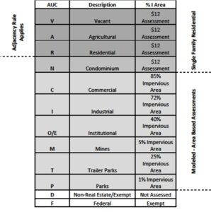
AUCs (Assessment Use Code) are determined by the MWCD Board of Appraisers. The AUC of a parcel is derived from the PUC of a parcel. For example, a PUC of 510 yields an AUC of R or Residential. The complete table of AUCs, with definition and estimated percent impervious area, follows:
The MWCD obtains parcel information from county offices annually. Parcel data that did not exist prior to the assessment was created and is updated annually using scanned paper tax maps from county offices. Attribute information for the parcels is obtained annually from each county office as well.
In order for parcels to qualify for the adjacency provision in the Maintenance Assessment Billing Policies, they must first meet some basic criteria. For adjacent parcels that are classified by the County Auditor as Agricultural, Residential or Vacant, having an AUC of either A, R or V, and have exactly the same ownership of record in the Auditor’s data, are consolidated and considered one ERU for the purposes of the MWCD assessment.
In the case of contiguous tracts of land where the AUC is either Agricultural (A), Residential (R) or Vacant (V):
- If a landowner’s names in the Auditor’s records do not match exactly, the landowner bears the burden of providing appropriate evidence that the landowners are exactly the same.
- If the tracts have multiple owners of record, the owners on all contiguous tracts of land must be exactly the same.
- If the owners of record are exclusively husband and/or wife, dower interest allows consolidation with appropriate evidence of marriage.
Parcels divided by a private or public road, stream, bicycle path or railroad are considered adjacent.
Access easements connecting two or more tracts of land with the same owner of record, where the access easement passes over land owned by a different owner of record, does not qualify parcels for adjacency and consolidation.
No. While the MWCD may review the assessment that is derived from the source data obtained from constituent counties, the MWCD is not authorized to change public records that are obtained from each county.
Each constituent county has its own approach for assigning PUCs. The MWCD does not offer advice on how to change a parcel’s PUC.
The assessment amount on a given parcel may change if the source data for that parcel changes. For example, if the PUC of a parcel changes, the assessment amount may change to reflect the new PUC. The minimum ERU rate is determined and set by the MWCD Board of Directors in accordance with Ohio Revised Code 6101. At this time, no change in the ERU rate of $12 is planned.
Parcel attribute information is obtained from constituent county offices beginning April 1 of each year. Parcel boundary information is then obtained throughout the summer. The assessment billing file is levied with each county no later than September 30th, and is placed on tax bills by the county the following year. Assessments that do not reflect changes to parcel attribute information or parcel boundaries that have occurred before September 30th may be subject to adjustment via the Request for Assessment Review process. Changes to parcel attribute information or parcel boundaries that occur after September 30th will not be reflected until the subsequent assessment year.
No. Current Agricultural Use Values (CAUV) and the Homestead Exemption are not considered in MWCD assessment methodology.
MWCD places an assessment on parcels of real estate, and views the payment of the assessment as the responsibility of the parcel owner. Whether or how the assessment is passed from the parcel owner to a lessee is at the discretion of the parcel owner.
Parcels in the Chippewa Subdistrict are assessed for the maintenance of the dams, reservoirs and other projects within the Chippewa Watershed. The MWCD Board of Appraisers recognizes that property within the Chippewa Watershed also contribute runoff, sediment and pollution to the Muskingum Watershed. Because of the runoff, sediment and pollution contributed to the Muskingum Watershed, the Chippewa SubDistrict property owners will receive an additional assessment but will be granted an up to 50% credit reduction to their Muskingum Watershed assessment. At this time, the combined Chippewa and Muskingum Watershed Assessment cannot be less than six dollars ($6).
MWCD offers a process for parcel owners who would like to have their assessment reviewed. Details can be found at our Request a Review page.
A review typically falls into one of three categories. They are:
- Adjacency Review: For parcels that have an AUC of A, R, or V, owner(s) name(s) that match exactly and are adjacent to each other (Billing Policy 4).
- Impervious Area Review: For those parcel owners who believe the impervious area computations (set forth in Billing Policy 14) are not representative of the actual impervious area and have additional information for re-evaluation.
- Property Use/Ownership Change: For those parcel owners with recently acquired property, or property with a recent PUC change. Documentation from the county of record must be provided by the parcel owner as proof of the change.
For a complete understanding of the Request for Assessment Review process, please see the Request for Assessment Review Process Summary page.
Parcel owners who believe they have overpaid assessments for previous years can file an Assessment Payment Verification Form. Supporting documentation in the form of proof of payment must accompany the Form. For examples of accepted forms of supporting documentation please see the Request a Review page.